
Holly Deyo
According to Irish Weather Online, the mayor of El Hierro, David Cabrera, confirmed in an interview on Radio Iron Garoé that an ‘underwater eruption’ is taking place about 900 metres beneath the sea surface and 3 miles south of La Restinga. The eruption, which has been ongoing for 4 hours, was triggered when a fissure opened after the 4.3 quake struck just off El Hierro’s coast Saturday. It’s not clear at this time if the volcano is spewing gas or lava. However, gases were detected 600 meters below the sea and about 7 miles from the La Restinga.
This is the first eruption since 1971, when the Teneguía volcano created a new crater.
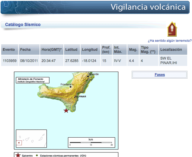
The National Geographic Institute, which records all the Canary Island volcanic and seismic activity, measured the event at 4.4 mag. Small difference, but monitors closer to an epicenter usually show the magnitude slightly higher.
When checking 7 reporting sites: USGS, IRIS, Google Earth, GFZ Potsdam, Switzerland’s Red Puma, and Germany’s EQ Mashup, only Europe’s ESMC shows it. The first 6 show NO quake activity whatsoever on El Hierro for the last three months. Zip. Zero. Nada.
NONE of the nearly 10,000 quakes show up on Google Earth, no matter how big the map is enlarged. Then again, Google Earth uses a USGS feed for quake reports and it shows a totally clean slate for the Canaries. Right…. It’s as though none of the massive number of quakes has happened.
Even though USGS does not show quakes less than Richter 4.5 for Worldwide events, with a swarm this massive one would think the Canary events would garner some attention. However, Red Puma has no such excuse and though IRIS records events down to 4.0, they nothing show on their maps.
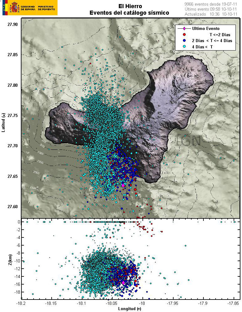
In this image below, red dot quakes are less than 2 days old, blue dots are 2-4 days, cyan dots are over 4 days and the pink diamond locates the last event. You can see quakes are progressing to the Northeast – with any shock waves angled away from Cumbre Vieja.

Be the first to comment on "Who’s Covering Up El Hierro’s Quakes?"