
In a world where conflicts often unfold far from the public eye, satellites are quietly becoming witnesses from above, documenting destruction, displacement, and crimes that would otherwise remain hidden. The United Nations Satellite Centre (UNOSAT), a programme under UNITAR, has launched an initiative titled “Satellite Imagery as Evidence in International Justice Proceedings”, a pioneering effort to bridge the gap between technology and international law. Its mission: to ensure that images captured from space can stand as credible, comprehensible evidence in courtrooms investigating war crimes and human rights abuses.
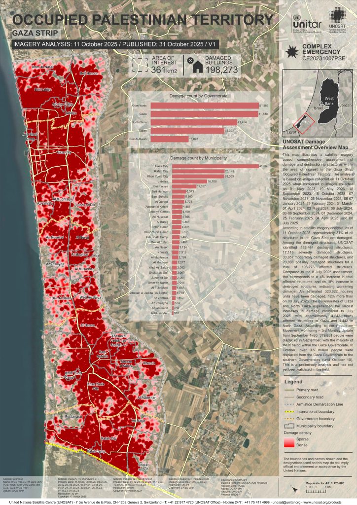
A recent report from UNOSAT reveals widespread destruction across Gaza as of October 2025. Satellite analysis by UNOSAT indicates that as of 11 October 2025, an estimated 81% of all buildings in the Gaza Strip have sustained damage. The assessment identifies 123,464 structures completely destroyed, 17,116 severely damaged, and 33,857 moderately damaged, bringing the total to 198,273 affected buildings—a 4% overall increase and an 18% rise in total destruction since July 2025. Roughly 320,000 homes have been damaged, up 12% in three months. The Gaza and North Gaza Governorates suffered the sharpest escalation. Over half a million residents were displaced in October alone. These findings remain preliminary and await on-ground verification.
MAP: UNOSAT damage assessment overview map of the Gaza Strip in the Occupied Palestinian Territories (OPT) (Source: UNOSAT)

One of the defining elements of genocide is the intent to destroy a protected group, in whole or in part. In Gaza, where independent access is severely restricted, satellite imagery has become a crucial witness from above. These high-resolution images reveal the widespread demolition of homes, farmland, and vital infrastructure—evidence that destruction is not random, but systematic. By tracking changes over time, analysts can trace a clear progression: neighborhoods emptied, fields razed, hospitals reduced to rubble. Such visual records not only bring transparency to otherwise inaccessible war zones but also help investigators piece together a pattern of deliberate displacement and deprivation—hallmarks of mass atrocity.
The Challenge: Turning Pixels into Proof
In many crisis zones, from bombed-out villages to scorched farmland, satellite imagery is sometimes the only independent record of what really happened. Yet despite its power, this data often struggles to make its way effectively into legal proceedings.
“Satellite imagery analysts can detect patterns of destruction,” the project notes, “but they are rarely trained in the evidentiary standards required in court.” Conversely, prosecutors, judges, and defence lawyers may not know how to interpret the technical nuances of imagery or assess its reliability.
This disconnect between legal and technical worlds has long been a weak link in the chain of international justice, one that UNOSAT now aims to strengthen.
Building a Common Language
At the heart of the initiative is a simple but vital goal: training both lawyers and analysts to speak each other’s language.
The project involves a series of consultations, workshops, and tailored training modules designed to help legal professionals understand the science behind satellite imagery and to help imagery specialists grasp the standards of admissibility, chain of custody, and courtroom communication.
Through this two-way learning process, participants develop the skills to transform a satellite image from a static picture into a piece of persuasive, verifiable evidence.
A New Frontier for Accountability
The implications are far-reaching. When properly used, satellite imagery can reveal mass graves, burned villages, or shifting front lines with remarkable clarity. It can corroborate witness statements, verify timelines, and provide documentation in areas too dangerous or remote for investigators to access.
UNOSAT’s project doesn’t just train individuals; it builds a shared framework of trust and understanding that could redefine how evidence is collected and presented in international courts.
As the initiative develops, it also plans to produce a policy brief and share lessons learned with the wider justice community, ensuring that this emerging practice is not confined to a single project but becomes part of a broader movement toward more transparent, technology-informed justice.
Seeing the Bigger Picture
The growing use of satellite imagery in human rights work is already reshaping accountability. But as UNOSAT emphasises, the technology alone is not enough. It must be paired with human expertise, ethical oversight, and legal rigor.
By teaching judges, lawyers, and analysts to interpret what satellites see, and to trust what they show, the project marks an important step toward a future where justice is not only sought on the ground, but also seen from above.
In essence, UNOSAT’s “Satellite Imagery as Evidence” project is about turning technology into truth, ensuring that, even from space, the world’s most serious crimes, like genocide, do not go unseen.
Freddie Ponton
21st Century Wire
READ MORE UNITED NATIONS NEWS AT: 21st CENTURY WIRE UN FILES
VISIT OUR TELEGRAM CHANNEL
SUPPORT OUR INDEPENDENT MEDIA PLATFORM – BECOME A MEMBER @21WIRE.TV


